
Geospatial analytics involves the processing and interpretation of vast amounts of data collected from various sources, including sensors on satellites, drones, and other platforms, to identify potential issues in various industry sectors. Satelytics is a software company, producing geospatial analytics for early detection, location, and – in many instances – quantification of customers’ most pressing challenges.
“We’re digesting big data, looking for signs of irregularities in fields that span thousands of square kilometers,” explained Jay Almlie, Chief Marketing Officer for the company. This approach is particularly beneficial for industries with assets spread over large areas, and for Satelytics, this means that their primary clients are in the energy industry, including oil and gas, pipeline operators, and utilities such as power, gas, and water.
“Monitoring such widespread assets using traditional methods like stationary sensors, drones, or airplanes is challenging,” Almlie said. “However, by leveraging satellite data and AI-based algorithms, we can quickly analyze large amounts of information and provide actionable alerts. This enables our clients to efficiently manage and monitor their assets, ensuring timely and effective interventions.”
“The ability to monitor these assets in real-time is not just revolutionary; it’s essential for maintaining infrastructure integrity and preventing potential disasters”.
How the Satelytics system works
At the heart of Satelytics operations is a sophisticated system that utilizes satellite imagery. “The sun shines off features on the Earth’s surface or gas plumes above it, and this reflected light is captured by satellites,” Almlie detailed. “Ninety-five percent of our operations involve satellites because they can cover the entire Earth, capable of a complete scan once per day. With numerous satellites in orbit, and due to our data-agnostic nature, we now achieve multiple daily captures, enabling us to analyse data frequently. This data consists of reflected light, which contains spectral information.
“Specifically, we focus on the near-infrared and shortwave infrared regions of the electromagnetic spectrum, as they provide rich data,” he added.
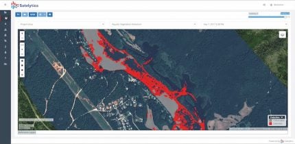
“We analyse spectral signatures, which are like fingerprints or DNA. For instance, a healthy oak tree has a different spectral signature than an unhealthy one, a maple tree, subaquatic vegetation, a gas leak, or a hydrocarbon leak.”
One of Satelytics’ notable clients is Georgia Power, a US-based utility managing hydroelectric reservoirs. Traditional monitoring methods, which involved physically inspecting vast shorelines, were time-consuming and inefficient. With Satelytics, Georgia Power can now receive daily updates on the state of their reservoirs, identifying issues like unauthorized dock constructions or the growth of invasive species.
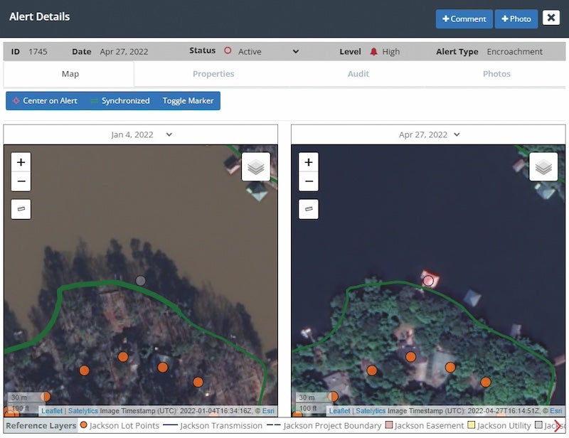
“We can generate actionable alerts within hours of satellite data capture, enabling prompt responses to issues,” Almlie said. “This proactive approach is far superior to traditional methods that might reveal problems months later.”
Satelytics delivers these alerts and data through a mobile app, a web-based interface, or various APIs. Companies like Georgia Power can integrate these alerts into their existing workflows. Satelytics’ APIs act as translators, converting data, results, and alerts into a format that different software can seamlessly integrate. This allows the company to directly feed insights into clients existing business systems. This integrationenables them to manage tools, personnel, and resources efficiently, ensuring timely problem resolution and tracking.
For Georgia Power, specifically, monitoring jagged reservoirs from the shoreline would take weeks or months manually. Using satellite data, Satelytics can quickly identify unauthorized dock installations, monitor the growth of subaquatic vegetation like hydrilla, and address issues impacting water quality and hydroelectric systems.
Satelytics has a team of remote sensing specialists whose job is to interpret spectral signatures, then design algorithms to do the same, automatically. “There are existing spectral reference libraries for almost everything,” Almlie explained. “For example, we can identify the spectral signature of a healthy oak tree versus an unhealthy one. Our algorithms compare sensor data against these standard spectral signatures, allowing us to quickly determine if what we see matches our expectations. This process applies to subaquatic vegetation, land movements, and shoreline erosion.
“All of our algorithms analyse the same set of data. We simply activate or deactivate specific algorithms as needed, and we have over 40 algorithms available. One of our core principles is demonstrating to companies that a single set of data can provide multiple answers. By utilising as many algorithms as possible, at little or no additional cost, we help solve various problems across an organisation. This is the significant benefit of geospatial analytics: it no longer addresses a single issue but can resolve multiple issues simultaneously by leveraging existing data in new ways.”
Overcoming challenges
Adopting new technology always comes with challenges. Almlie acknowledged that utilities are often cautious and can be overwhelmed by the volume of data provided. “The biggest challenge we encounter is that utilities often struggle to adopt new technology,” he said. “They tend to be very cautious, so when we deliver more alerts and data than they expected, they can feel overwhelmed. They worry about how to handle all the information and their legal obligation to act on it. To address this, we work closely with our customers to ensure we provide manageable amounts of information. We stage the work to fit their workflow processes, ensuring they have enough resources to act on the alerts they receive. This is both our biggest challenge and our greatest opportunity.”
Another common scenario, Almlie explained, is when a utility approaches the company with a specific problem or even multiple problems. Once they start working together, they often realize they have additional issues they need help with. Sometimes these new problems require Satelytics to develop new algorithms.
In these cases, the company collaborates with the customer to gather field data and test the algorithm, which self-corrects through machine learning. This process, known as ground truthing or calibration, ensures the results are accurate.
“We can often achieve 90% accuracy within two or three data captures. The customer is pleased with the outcome, and we gain a new algorithm, which they helped develop to solve their problem,” Almlie said.
Expanding horizons
While Satelytics primary focus has been on energy sectors, the potential applications of its technology are vast. From environmental impact assessments to monitoring sedimentation in reservoirs, the versatility of geospatial analytics is evident. Almlie shared: “We’re already working with companies in the UK on projects like pipeline and rail construction, helping them identify ancient burial grounds and other environmental factors.”
One of the services the company provides for utility customers in the US is pre- and post-storm damage assessment, particularly in regions prone to hurricanes, such as the east and south coasts. Using satellites, the company can identify specific locations of concern to infrastructure. This same technology can be applied to assess sites for future infrastructure projects, such as dams or transmission towers.
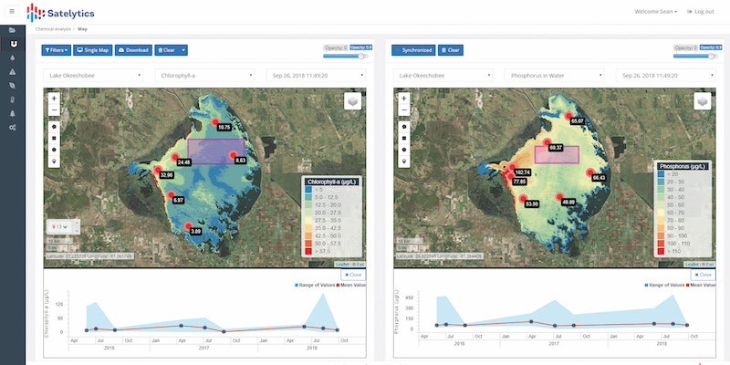
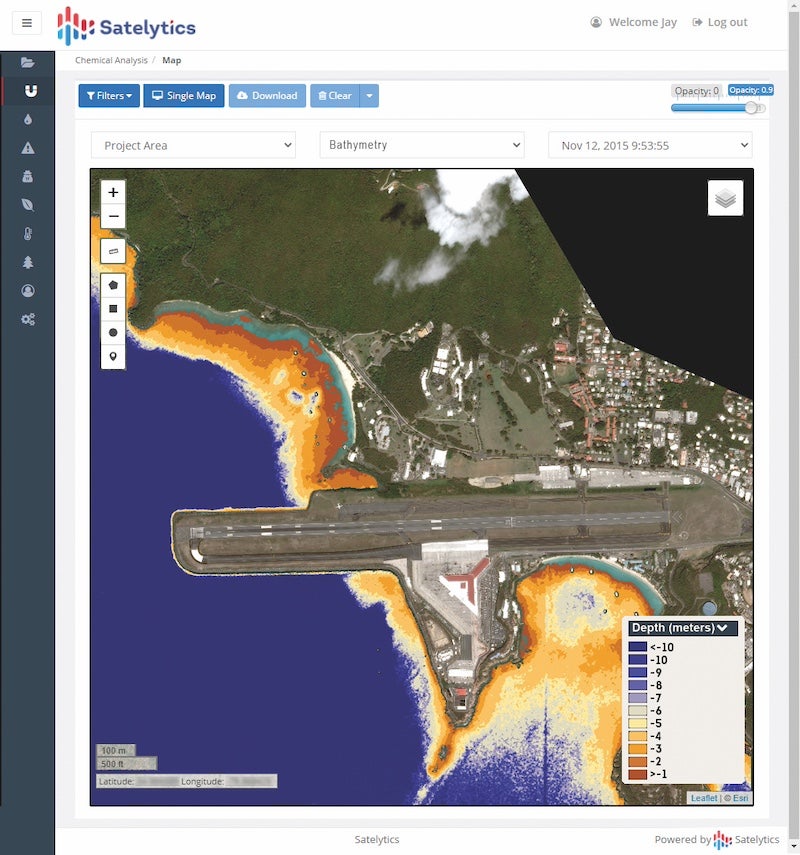
Additionally, there is a land movement algorithm to monitor erosion and water quality algorithms that detect specific constituents in the water, including arsenic, barium, manganese, iron, aluminum, nitrogen, and phosphorus. These are crucial for water body managers.
“However, if a utility needs to detect something we don’t yet have an algorithm for, we can develop a new solution,” Almlie said. “Instead of waiting for laboratory analysis of thousands of costly point samples, utilities can use satellite data for a more efficient and comprehensive analysis.”
As utilities face increasing pressures from environmental regulations and the need for efficient operations, the demand for advanced monitoring solutions like those offered by Satelytics is set to grow. The ability to detect and respond to issues swiftly not only enhances operational efficiency but also contributes to environmental conservation efforts. By leveraging the power of geospatial analytics, Satelytics can provide a level of insight and responsiveness that was previously unattainable. As Almlie aptly put it: “We’re not just solving single problems; we’re enabling utilities to address multiple issues simultaneously with the same set of data.” This multi-faceted approach not only optimizes operations but also paves the way for a more sustainable future in utility management.


