
The preservation of natural ecosystems has to be balanced alongside the growing demands of the water-energy-food sectors in the Andes-Amazon region – all in the face of imminent climate change. And in an effort to help food and energy systems adapt to climate change, researchers have developed a framework of catchment and hydropower models that consider climate and other uncertainties in the Andes.
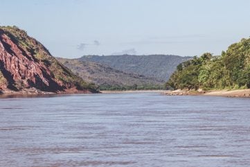
The upper Huallaga Basin is part of the Marañón River in Peru, which is a major tributary of the Amazon. It was recently part of a study to explore reducing sectoral conflicts when addressing the water-energy-food-ecosystems (WEFE) nexus within the Andes-Amazon. Understanding watershed processes and the multiple pressures and conflicting objectives that need to be reconciled between them, is considered to be a critical component to managing WEFE systems under climate change.
As Ding et al explain in their study in Communications Earth and Environment, the environmental challenges facing the Andean headwater basins of the Amazon have been under-explored in existing literature. These basins are not only key for providing food and income for thousands of rural and indigenous families, but could also play a key role in the regional transition to renewable energy.
Characterised by a patchwork of native Andean ecosystems and family farming systems, agricultural productivity in the Huallaga Basin is low, with levels of economic poverty and undernutrition high. This therefore means improving agricultural livelihoods is a central issue for improving food security and advancing human development, the authors state.
The upper Huallaga River also provides water to the 450MW Chaglla Dam – Peru’s third largest hydroelectric plant.
“Despite impounding a major reservoir, the plant has limited capacity to buffer inflows because it is operated like a run-of-river plant,” the authors explain. “Energy generation at weekly to monthly scales thus relies mainly on the hydrological functioning of the upper Huallaga Basin. Specifically, dry season low flows (from June to November) determine the plant’s capacity to deliver firm power, an indicator for the reliability of power generation, which is critical for the plant’s operational and financial baseline.”
Challenge
The Andean headwaters of the Amazon are described as being symbolic of the challenge of meeting demands from the interconnected water-energy-food sectors, while enabling ecosystem conservation. Indeed recent decades have borne witness to rampant deforestation and degradation within the region – with severe consequences.
“Exploring the environmental challenges and opportunities to reconcile the dual imperatives of nature conservation and restoration along with human development is urgent in these geographies,” the authors state.
Utilising 10,080 possible land use/management adaptation pathways, the research study found limited opportunities for win-win solutions under climate change. In the light of such challenges, the authors say their results highlight the need for navigating structural trade-offs between upstream land and water users and downstream interests in the Andes, in a strategic and equitable manner. But as their results highlight, although irrigation will be critical for maintaining food production under climate change, any unplanned expansion could lead “to a near total loss of firm hydropower downstream”.
According to the Ding et al, their findings “are of importance for the entire Andes-Amazon region”, where current (6700MW) and future (up to 39,000MW) hydropower production intersects with opportunities to intensify agriculture, along with governments’ ambitions to restore and conserve ecosystems.
Without regulation and efficient irrigation practices, it is likely that widespread and unplanned adaptation of irrigation could hamper downstream hydropower generation, a major source of renewable energy.
“Trade-offs between hydropower and agriculture are often framed with respect to the potential conflicts of upstream dam operations with downstream irrigation,” the authors continue. “However, impacts are mutual, with a major dependence of dams on the management of upstream catchments. This is particularly evident for hydropower facilities with little regulation capacity which are vulnerable to small changes in the timing and magnitude of low flows.”
Previous studies of the lowland Amazon have highlighted the risk that deforestation creates for hydropower outcomes, the authors admit, but state: “these findings did not shed light on complex upstream-downstream trade-offs nor identify opportunities to actively influence hydropower outcomes through proactive catchment management”.
Such trade-offs are described as being much harder to navigate in the more densely populated landscapes of the Andes-Amazon, since large-scale conservation might benefit hydropower and ecosystems but would also negatively impact many rural and indigenous families’ livelihoods and food security. Ding et al say their results provide evidence that future approaches must incorporate possible impacts from both climate and upstream land use change to be able to judge future hydropower outcomes in a robust manner.
Although they say their results indicate that win-win situations across all sectors are elusive in the Andean Amazon, the authors go on to state that: “robust planning with a trans-sectoral approach to watershed processes, climate, and engineered systems will be critical for effective and equitable climate mitigation and efforts to restore terrestrial ecosystems in the Andes-Amazon and beyond”.
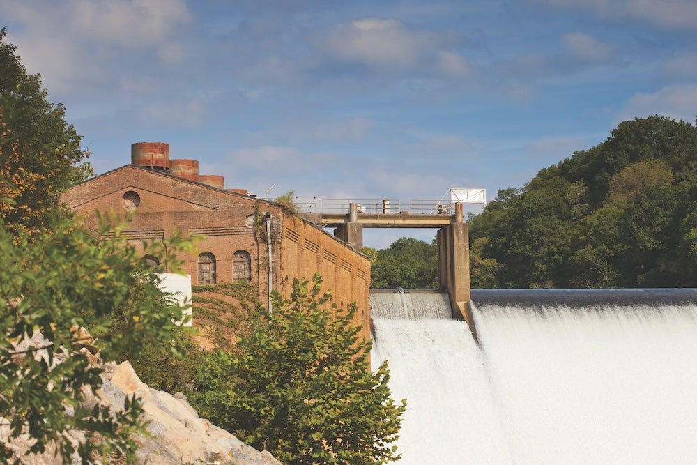
TVA flood mitigation
Flood mitigation strategies prevented approximately US$406 million of potential damages when two months of normal rainfall fell in three days on the Tennessee River Watershed, during September 2024.
Tennessee Valley Authority data collected during and after Tropical Storm Helene landed in the US, provided insight into the magnitude of the storm that swept across the Appalachian region from 27 September.
The seven-day rainfall average in the eastern Tennessee River Valley on September 29 was 719.5cm, approximately ten times the normal amount of rainfall that occurs in a normal week in late September. And between 29 September to 5 October, TVA’s hydro units generated an average of 2869MW a day, which is 1600MW greater than the average during the same timeframe in 2023.
Significant and catastrophic flood damage to communities occurred throughout northeast Tennessee and western North Carolina. These were areas where its flood control operations could not mitigate impact, TVA said. When that floodwater began flowing into the Tennessee River watershed, its network of dams, and employees, were already at work to protect people downstream.
“Greene County was aided immeasurably by engineer representatives from TVA from the very early stages of the storm and flooding affecting Greene County,” said Greene County Mayor Kevin Morrison. “TVA’s timely, accurate, and wise forecasting and professional advice to our leadership team on the conditions of the Nolichucky River and the Nolichucky Dam saved lives.”
Providing flood control of the Tennessee River is a core mission of TVA and has been since its inception more than 91 years ago. Evaluating rainfall and stream flow data from across the valley provides engineers in TVA’s state-of-the-art river forecast centre the information to make operational decisions to minimise flood impacts along the river system.
Using computer modelling, TVA tracks what might have happened without dams and flood mitigation as a way of helping determine how well its system is operating. That data collectively informs “flood damage averted” calculations.
Data from this event shows that flood mitigation strategies enacted by TVA prevented approximately US$406 million of potential damages in Lenoir City, Chattanooga, Kingsport, Elizabethton, Clinton, and South Pittsburg. Since TVA’s inception in 1933, more than US$10 billion in potential flood damage has
been averted.
“This was some of the highest flood levels we’ve seen in the Tennessee Valley in its entire history,” says James Everett, TVA’s General Manager of River Management. “We saw a record amount of flooding and we saw tremendous amounts of rainfall that caused that flooding. TVA’s dams and the people who manage these dams stepped up to the challenge and managed this record setting event.”
The reservoir system and its ability to store water during floods led to significant overall reduction in flood crests in communities along the river system. Without TVA’s system of dams, the river stages at Lenoir City and Chattanooga would have been about 6.4-7m higher than the observed levels during Helene.


