
Ecuador’s largest hydropower facility is under threat after a natural disaster has led to catastrophic river erosion. US scientists are now helping to advise the Ecuadorian government on the best way to handle the resulting sediment deposition in order to maintain the sustainability of the project.
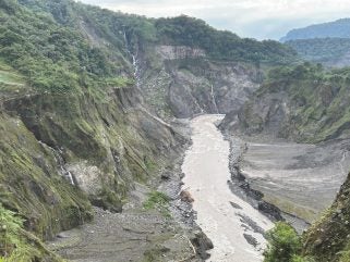
The US Geological Survey (USGS), the US Army Corps of Engineers and other federal agencies are working with the Electric Corporation of Ecuador (CELEC) on strategies for managing sediment and erosion in the Río Coca river basin, following the collapse of the 144m tall San Rafael waterfall in 2020. Catastrophic erosion of the river valley has been taking place upstream of the waterfall collapse, causing landslides and infrastructure damage. As the erosion has rapidly migrated upstream, over US$3 billion of Ecuadorian infrastructure, including the Coca Codo Sinclair (CCS) hydropower facility, is under threat.
During a visit in January 2024, USGS scientists observed substantial river channel shifts and upstream migration of the erosion, which was about 7km downstream of the intake to the CCS hydropower facility. The scientists also visited and assessed the extent of sediment migration to the lower reaches of the river, downstream of the waterfall collapse. In addition to effects of the 2020 incident, the same hydropower facilities are threatened by reservoir sediment accumulation upstream of the CCS intake.
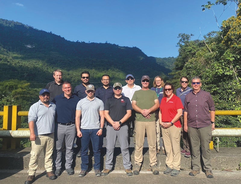
CELEC leadership expressed support for continued US assistance and for a USGS proposal to implement a watershed monitoring plan for sediment and streamflow. Such data will be vital for sustainability assessments of infrastructure and implementation of sediment and erosion management strategies.
Klamath River sedimentation
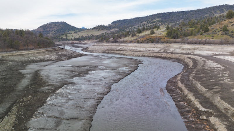
With drawdown of the four US dams slated for removal on the Klamath River now completed, the river is reshaping itself by removing decades worth of accumulated sediment. During March and April 2024, NOAA Fisheries and the US Bureau of Reclamation worked with tribes and other basin partners to release water from the Link and Keno dams farther upstream to create a flushing flow that doubled the river volume, picking up sediment and flushing it downstream and into the ocean.
Such measures offered the river its best opportunity to move sediment that had built up behind the Iron Gate, Copco No and 2, and JC Boyle Dams over the last 60 to 100 years. The goal was to maximise the amount moving down river while reducing risk to fish released from hatcheries and others migrating in the river. Studies anticipated that sediment mobilising in the first months of dam removal would muddy the river, as turbidity naturally rises with higher winter flows. Although it was anticipated this would have some short-term impacts on fish this year, the strategy of concentrating the movement of sediment over a few months will avoid impacts on fish spawning and hatching in future years.
“The river is undoing a century of being impacted by these dams, and that may look messy right now,” said Shari Witmore, a fisheries biologist in NOAA Fisheries’ Klamath Branch. “It’s moving all that sediment faster and more efficiently than we ever could, so what we are seeing is a very good thing.”
Hydropower cascades
Sediment deposition has become “an extremely constraining factor for large reservoir groups” according to research by Jun Li et al. Admitting that it can be difficult to estimate and understand sediment deposition when designing and managing reservoirs, the authors say it is nonetheless important because the joint operation of cascade reservoirs not only affects the utilisation efficiency of a specific reservoir, but it can also affect:
- The sediment boundaries of other reservoirs in the group.
- The comprehensive benefits of the entire cascade reservoir system.
- The regional water ecological environment.
Sediment deposition is a key factor to be considered when designing and monitoring the operation of multi-reservoirs, and in-depth research is required to ensure that cascade reservoir benefits are optimised.
In their research, Li et al focus on the Baihetan Reservoir in China which was constructed as part of the second stage of building four cascade power stations in the lower Jinshajiang River, with initial water storage officially beginning in April 2021. Previous studies on sedimentation here were mostly based on the use of simulation predictions during the design stage, and relatively minimal research on actual sedimentation has been conducted. In this study, rich hydrological and topographic observation data from the Baihetan Reservoir area were used to analyse the characteristics of sediment deposition during the initial period since its inception.
The results showed that water entering the reservoir was mainly derived from the upper mainstream, with ten times the amount of sediment derived from the mainstream received from tributaries and uncontrolled areas of the reservoir. The fluctuating backwater area influenced by the upstream Wudongde Reservoir was slightly eroded, and siltation mainly occurred in the dead storage capacity (below 765m) of the mainstream and tributary estuaries in the perennial backwater area.
According to the authors, the differences between these results and those from the reservoir demonstration stage indicate “a lack of understanding about how climate change, human activities, and uncontrolled areas would affect siltation patterns”. They recommend that for future projects, research focusing on climate trend analyses and the comprehensive consideration of human activities should be combined with extensive sediment production monitoring and model parameter calibration.
Spawning and sediment
In their research focusing on the upper reaches of the Yangtze River in China, which is the largest group of hydropower cascade projects on the world, Yinjun Zhou et al discuss how such hydropower systems can impact flow regimes and sediment transport in rivers, ultimately affecting fish spawning. Previous studies, they add, have examined the effects of fluctuating flow and water temperature on spawning; however, insufficient attention has been paid to their effects on sediment transport.
This study analysed changes in runoff and sediment load in the upper reaches of the Yangtze River over the past 60 years, as well as investigating the effects of cascade hydropower operations from 2009-18 on the spawning abundance of Coreius heterodon in the upper Yangtze River Fish Reserve.
The results showed that sediment load and sediment concentration decreased by 56.8% and 56.6%, respectively. This, along with changes in flow regime, led to a reduction in the spawning abundance of this fish species. These findings, the authors say, are critical for evaluating the long-term impacts of cascade hydropower on fish habitats and provide indispensable support for the sustainable operation of such projects.
Mitigating impacts
The potential for dam operations to mitigate their impact on sediment dynamics while preserving hydropower generation targets has not been explored, according to Invernizzi et al. Determined to rectify this, they undertook research looking at the Sekong, Sesan, and Srepok (3S) river basin, an important tributary of the Mekong River which flows through Cambodia, Lao PDR and Vietnam.
More than 50 dams have been built over the last two decades and to evaluate their impacts and their re-operations on sediment trapping and routing, the authors developed an integrated modelling framework combining models of hydrological processes, dam operation, and sediment connectivity. Their results indicate that the 3S river basin has lost approximately 60% of its annual outlet sediment load due to the cumulative impact of its largest hydropower dams. Moreover, the basin is experiencing an annual loss of approximately 0.32% of its total water storage capacity due to sediment trapping by reservoirs. However, smaller reservoirs are experiencing more pronounced reductions in storage capacity with losses reaching up to 3% per year. Ultimately, reservoir sediment depositions and the subsequent decrease in storage capacities are impacting reservoir water releases and, consequently, hydropower production. Despite being minimal, the interaction between hydrology and sediment dynamics exists, and are likely to accumulate as dams continue to operate over long horizons.
After further modelling their analysis revealed that the operational space of the existing reservoir configuration is limited, and dam reoperation can only marginally enhance the 3S sediment loads. This outlines the importance of integrating reservoir water release strategies with sediment release policies, such as drawdown flushing. By considering such measures, Invernizzi et al say the trade-off between hydropower production and outlet sediment loads would have been more pronounced. Consequently, the re-operation of dams could play a more significant role in mitigating hydroelectric production losses.
Situation in Vietnam
The Vu Gia Thu Bon (VGTB) river basin in Vietnam is ranked as the country’s fourth highest in hydropower potential but faces difficulties in maintaining water supply and controlling saltwater intrusion. In turn this is proving to be a challenge for the local population’s domestic and agricultural water supplies.
Research by Bonh Quang Nguyen et al in Scientific Reports explains that hydropower development in the region has become a focal point for discussion and has highlighted the complexities of water resource management. Their findings show that dam development, sand mining and changes in land use are the main factors responsible for the decreased flow discharge and sediment morphodynamic alterations, which have led to riverbed incision and saltwater intrusion in recent years.
The authors warn that future increased urbanisation in the study area will be accompanied with an increased demand for water supplies, and will be further compounded during times of drought. They say their findings provide a scientific basis for policymakers and decision maker to design and implement an effective and integrated approach to water resource management in the river basins to ensure sustainable future development.
“A complex river network connects the VGTB River basin,” the authors conclude. “Therefore, to investigate the basin in detail, especially under the impact of climate change and anthropogenic activities, it is necessary to collect data and establish a full hydro-sediment-morphodynamics model. From there, we can fully understand the effects of cascade dams, sand mining, and diversion on flow discharge, sediment budget, and morphological change.”


