Cloud-seeding initiatives
4 January 2010A world-first cloud seeding research project is being used to help direct future water resource management programmes in Australia
Drought is an all too familiar concern for many Australian communities. In fact, due to several years of reduced rainfall and a continually increasing population, the region of southeast Queensland, which includes the Brisbane metro area, has experienced looming water shortages that resulted in regulated water restrictions and a quest to find solutions to their potential water resource crisis. As a response, the Queensland government invested resources into studying the feasibility of precipitation enhancement via cloud seeding to supplement water resources.
What is cloud seeding?
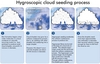
When a cloud forms, moisture in the form of water vapour is carried into the cloud until it condenses on particles into liquid water, thus forming cloud droplets (see Figure 1, part 1). The cloud droplets are very small and cannot readily fall out of the cloud, therefore other processes must occur to grow the liquid cloud droplets large enough to fall as rain.
One such process is called collision and coalescence, in which cloud droplets of a variety of sizes (which fall at different speeds to one another) collide with each other and coalesce into a combined larger drop (Figure 1, part 2). This process continues until drops are large enough to overcome the updraft speed within the cloud and fall as rain.
In addition to processes that help the droplets grow, there are factors that can deplete the liquid water from eventually becoming rain on the ground, such as evaporation of the droplets or the freezing of small droplets (that were carried to the sub-freezing cloud top by the updraft) into small ice crystals that are unable to fall as precipitation (known as cloud glaciation). The amount of water vapour that enters a cloud never all falls to the ground as rain.
The precipitation efficiency (or the percent of incoming cloud water vapour that falls as rain) varies from cloud to cloud. Cloud seeding technologies aim to convert more of the water vapour processed in the cloud to more rainfall at the ground, thereby increasing the cloud’s precipitation efficiency.
Science-based technology
Cloud seeding is a science-based technology that aims to add particles to a cloud that will help precipitation develop more efficiently, thus hopefully yielding more rainfall. The type of particle added to the cloud depends on the characteristics of the clouds that will be seeded.
Deep clouds that have portions growing in sub-freezing temperatures may be seeded with silver iodide, a material whose properties are very similar to an ice crystal and serve as good surfaces on which ice can form.
Supercooled liquid water (liquid water that has been carried into sub-freezing temperatures, but has yet to freeze) can freeze on these silver iodide particles and initiate and enhance ice-based precipitation formation processes at key levels in the cloud, and prevent loss of that water to glaciation aloft.
Other clouds may be seeded with hygroscopic materials (particles that take on water easily, such as salts) in the updraft region of the cloud just below the cloud base (Figure 1, part 3).
These hygroscopic particles are then carried into the cloud by the updraft. Water vapour condenses on them to form additional liquid cloud droplets, whose size depends on the size of the hygroscopic particles introduced in the cloud. Adding additional particles of larger sizes may help enhance collision and coalescence processes that are responsible for rain formation and convert more of the cloud water to rainfall. In essence, a more efficient collision and coalescence rain formation process yields more rainfall at the ground (Figure 1, part 4).
The hypothesis for a propagation of the hygroscopic seeding effect is summarised in the box below. Note that the seeding conceptual model primarily focuses on aspects related to the sizes and concentrations of water droplets and ice crystals (generally referred to as the cloud microphysics) of the hypothesised response to cloud seeding.
However, based on previous hygroscopic seeding experimental results from South Africa and Mexico, additional effects (seeded clouds rained for longer periods over a larger area than natural clouds) possibly related to cloud air motions (cloud dynamics such as enhanced cloud growth due to possible modification of the updraft/downdraft structures and/or the development of progeny clouds) had to be invoked to explain the statistical results (Foote and Bruintjes, 2000). These aspects are as yet not well understood.
Assessing feasibility
The potential for such manmade increases in precipitation is strongly dependent on the natural microphysics and dynamics inside the clouds that are being seeded. These factors can differ significantly from one geographical region to another, as well as during and between seasons in the same region. In some instances, clouds may not be suitable for seeding, or the frequency of occurrence of ‘seedable’ clouds may be too low to warrant the investment in an operational cloud seeding programme.
Measurements of air and cloud properties in a specific region are also necessary to determine if the clouds are ‘seedable’. These factors need to be evaluated from a climatological perspective as part of an overall feasibility study. Such a study would also determine which seeding method should be used in the given region.
Likewise, it is important to conduct hydrological studies relating rainfall with river flows and reservoir levels, to determine hydrological regions where reservoir catchments are most efficient, and to calculate cost-benefit ratios for the specific region. Seeding could then be optimized by preferentially targeting the most efficient watersheds.
The effects of the cloud seeding technique(s) then need to be evaluated, which is often done using a randomization procedure to demonstrate statistically if and how well the seeding method works, and to quantify the increases in rainfall achieved. Typically this technique has relied on statistical evaluation of the storm water mass, rainfall rate, duration, size, and radar reflectivity; parameters generally derived from basic weather radar observations.
Nonetheless, because of the very large natural variability in storm characteristics and the local meteorological environment that can dwarf any cloud seeding effects, a large sample size of randomized seeded and unseeded cases is required to obtain statistical significance. Even with large sample sizes, however, there could still be ambiguity in understanding the physical mechanisms that were responsible for any seeding effect the statistical analysis might have suggested.
The Queensland project was undertaken in the hopes that through the use of physical measurements, such as those measured inside clouds by aircraft and remotely-sensed observations from state-of-the-art weather research radars, precipitation microphysical processes could be more directly observed. This could make it possible to understand cause and effect seeding relationships, thus not having to solely rely on statistical means that often generate controversy.
The Queensland example
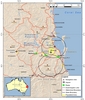
Scientists from a group of different bodies conducted the feasibility study for rainfall enhancement via cloud seeding during the summer rainfall regime in Southeast Queensland in Australia (Figure 2). The feasibility study, known as the Southeast Queensland Cloud Seeding Research Programme (CSRP), included a range of measurement systems, some using novel technologies.
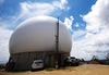
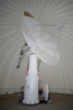
In situ cloud microphysical measurements in seeded and unseeded clouds were taken with an instrumented research aircraft, and randomized cloud seeding was performed by aircraft with seeding capabilities (see Figure 3). The most unique aspect of this study was the availability of a dual-polarization, dual-wavelength Doppler weather research radar (called CP2; Figure 4), in combination with other local BOM Doppler weather radars.
This is the first cloud seeding experiment in the world that has had a dual-polarisation, dual-wavelength radar available, which aids in discriminating microphysical precipitation processes, in addition to dual-Doppler radar coverage that provides three-dimensional airflow within the observed clouds. This is significant in that it is the first time the potential exists to observe the evolution of microphysical precipitation processes, such as precipitation particle type, number, and size, within a seeded cloud while at the same time observing the air flow patterns within the cloud.
The specific aims of the Queensland CSRP are to:
• Understand the rainfall and weather patterns in the southeast Queensland region to determine the frequency of clouds suitable for seeding.
• Collect detailed physical measurements of the cloud and precipitation processes to infer how cloud seeding may be impacting those processes.
• Conduct a statistical randomized cloud seeding experiment to estimate if cloud seeding is enhancing rainfall in the region.
The Queensland CSRP research is ongoing, however initial results have been presented to the Queensland government and will be used as guidance for planning future water resource management programmes, including assessing the potential of an operational cloud seeding programme to enhance rainfall in the region.
The authors are Sarah A. Tessendorf and Roelof T. Bruintjes, NCAR/RAL, P.O. Box 3000, Boulder, CO 80307, US. Email: saraht@ucar.edu
The Queensland Cloud Seeding Research Programme was sponsored by the Queensland Government Department of Environment and Resource Management through the Queensland Climate Change Centre of Excellence. Graphics for this article were produced by Kevin Sampson, Cindy Halley-Gotway and Lara Ziady (NCAR)
| Steps in the hygroscopic seeding conceptual model |
| 1) Hygroscopic seeding produces larger cloud droplets near cloud base |
| Research programme |
| Scientists working on the Southeast Queensland Cloud Seeding Research Programme included representatives from: |