Lessons learnt from the Wenchuan earthquake
11 September 2009Several dams and power plants damaged by the earthquake which occurred in China’s Sichuan province on 12 May 2008 were visited during a joint mission of the Chinese Committee on Large Dams and ICOLD’s Committee on Seismic Aspects of Dam Design from 29 March-4 April 2009. Here, Martin Wieland and Chen Houqun discuss the unique features of this earthquake and the damage caused, while addressing the question of the earthquake being triggered by Zipingpu reservoir
In the afternoon of 12 May 2008 a magnitude 8 earthquake occurred in China’s Sichuan province with the epicentre at a distance of 17km from the Zipingpu CFRD. The earthquake ruptured a 240km long segment of the Longmenshan fault system separating the Tibetan Plateau from the Chengdu Basin and is referred to as the Wenchuan earthquake. The main seismological features and damage to buildings and infrastructure of this earthquake are described by Wang et al. (2008) and others. A summary of dams and reservoirs affected by this destructive earthquake is given in Table 1. A more detailed description of the effects on large dams is given by Chen (2008) and Xu (2008).
The main features of interest to dam engineers are as follows:
• Local magnitude: 8
• Maximum recorded peak ground acceleration: 958cm/s2 (horizontal component) and 948cm/s2 (vertical component);
• Duration of strong ground shaking 90 sec to 120 sec; and
• Maximum fault movement at surface: 4.7m (horizontal) and 4.8m (vertical).
The main phenomena of this earthquake relevant for dams are as follows:
• High intensity of ground shaking and long duration.
• Large number of rockfalls blocking access roads to dams, causing damage at dam sites and locations of appurtenant structures, destroying masts of transmission lines, aqueducts, etc.
• Landslide dams blocking rivers at several locations.
• Overtopping of run-of-river power plants.
• Failure of hydromechanical equipment (gates, penstock), etc.
It was expected from the very beginning that mass movements (rockfalls, landslides) would be an important feature in this mountainous terrain with steep valleys.
Sichuan is the province with the largest hydro power potential in China with some 6678 dams and reservoirs. Some of the extraordinary projects completed recently are the 240m high Ertan arch dam, the 15m high Zipingpu CFRD, and the 132m high Shapai arch dam, the world’s highest RCC arch dam. Several very large projects are either under construction or under design such as the 278m high Xiluodu arch dam (12.6GW), the 186m high Pubugou earth core rockfill dam (3.6GW) and the 305m high Jinping 1 arch dam (3.6GW). However, only Zipingpu and Shapai dams were located relatively close to the ruptured fault segments and have experienced strong ground shaking as discussed in the subsequent sections. The other dams, as well as Three Gorges, were several 100km away from the epicentre and no damage was reported at these projects.
The Wenchuan earthquake affected more dams than any other previous earthquakes. It is also the most important seismic event to have occurred since the creation of the international-commission-on-large-dams’ (icold) earthquake committee some 40 years ago. Therefore, plans for a joint mission were discussed with Chinese colleagues at the ICOLD Annual Meeting in Sofia, Bulgaria in early June 2008. From presentations at the event however, it became clear that due to the large number of rockfalls and the interruption of roads in the worst hit area, a visit to major dams was not possible for the foreseeable future.
Finally at the 80th Anniversary Meeting of ICOLD in Paris in November 2008, a date could be fixed for a small joint ICOLD-CHINCOLD mission to take place in March and April 2009, approximately 11 months after the earthquake.
Thirteen foreign dam and earthquake experts from Austria, Canada, Japan, Switzerland, the UK, and the US participated in this mission, called the International Seminar on Earthquake and Dam Safety. The local arrangements were made by Jia Jinsheng (ICOLD President) and Chen Houqun on behalf of CHINCOLD. The program consisted of a one day seminar in Beijing where the participants were briefed on the Wenchuan earthquake followed by a three day visit of dam and run-of-river power plants in Sichuan, with a final one day seminar in Chengdu where dam owners and designers presented specific dam projects affected by the earthquake. Finally, a discussion was held in which (i) the personal experience gained from the mission, (ii) the lessons learnt, (iii) the topics for possible cooperation of ICOLD with CHINCOLD, and (iv) a paper on reservoirs and the Wenchuan earthquake were discussed.
At the beginning, some participants may have wondered if they could see anything at all so many months after the earthquake. However, it became clear to everybody after the first day’s visit to Zipingpu CFRD – the dam which was most easily accessible – that these concerns were not justified. During the field visit, seeing the huge number of mass movements and the serious damage to the transportation infrastructure, it became very obvious that a visit of the important dams and hydro power projects would not have been possible at an earlier date. As a matter of fact, traffic conditions along the main highway in the epicentral region were still very difficult leading to hours of waiting at some critical spots and it must be assumed that it was not possible until recently to move heavy construction equipment into some of the valleys where hydro power projects are located.
Therefore, the damage observed in these remote sites was still ‘fresh’, as can be seen from some of the photos.
This joint mission was a great success although only a fraction of dams damaged by the earthquake could be visited or discussed during the two seminars. This visit was really a unique opportunity for all participants interested in dams and earthquake safety.
In the subsequent sections the main lessons learnt from the Wenchuan earthquake by the authors are presented.
Special features of earthquake hazard in the case of storage dams
The exposure of dams to strong earthquakes may be a few seconds – at most – during their lifespan. Because strong earthquakes occur very rarely, few dam engineers or dam owners have any experience with them.
Strong earthquakes can affect a large area and many dams may be subjected to strong ground shaking. This has been the case for the Wenchuan earthquake. Different types of dams have been damaged; therefore the lessons learnt from this earthquake will be relevant for the whole dam industry.
It is well known that many existing dams were designed against earthquakes using seismic design criteria and methods of dynamic analysis which are considered obsolete, or even incorrect, today. This may also be true in China and it is expected that the seismic design criteria and methods of analysis and design will be reviewed and modified in the near future, as this has been common practice almost universally after a strong earthquake. In general it is easier to convince a dam owner to implement modern flood design criteria for his project, because the flood hazard is visible whereas the earthquake hazard is invisible.
The Wenchuan earthquake has confirmed that earthquakes are multiple hazards, which may have the following features in the case of storage dams:
• Ground shaking causing vibrations in dams, appurtenant structures and equipment, and their foundations (Figure 1).
• Fault movements in the dam foundation or discontinuities in dam foundation near major faults which can be activated causing structural distortions.
• Fault displacement in the reservoir bottom causing water waves in the reservoir or loss of freeboard.
• Mass movements (rockfalls, landslides).
• Ground movements and settlements due to liquefaction, densification of soil, causing distortions in dams.
Other effects such as water waves and reservoir oscillations are generally of lesser importance for the earthquake safety of a dam.
Usually the main hazard, which is addressed in codes and regulations, is the earthquake ground shaking. It causes stresses, deformations, cracking, sliding, overturning, etc. The other hazards may not be addressed because it is rather difficult to get any quantitative data of these hazards. Most analysts have difficulties with such hazards.
Mass movements and landslide dams
Due to steep slopes in the area, there were thousands of rockfalls and landslides in the Longmenshan fault zone. Over 2500 people were killed in two landslides in Wangjiayan, Beichuan county, Sichuan, each with an estimated volume of 10Mm3 (Wang et al., 2008).
In the case of storage dams the following features are possible and many have been observed during the Wenchuan earthquake:
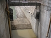
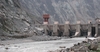
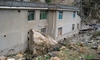
• Mass movements (rockfalls with large rocks) causing damage to spillway piers (cracks), retaining walls (overturning) (Figure 2), powerhouses (cracking and puncturing and distortions) (Figure 3), electro-mechanical equipment (Figure 4), hydromechanical equipment such as gates (Figure 5) and surface sections of penstocks, damaging aqueduct, overturning of masts of transmission lines (Figure 6), etc.
• Mass movements into the reservoir causing impulse waves in the reservoir.
• Mass movements blocking rivers and forming landslide lakes whose failure may lead to overtopping of run-of-river power plants or the inundation of powerhouses with equipment.
• Mass movements blocking access roads to dam sites and appurtenant structures (Figure 7).
During the Wenchuan earthquake some 33 major landslide lakes were created. Tangjiashan landslide dam with a height of 124m and a volume of about 2Mm3, which stored 320Mm3 of water, caused a major threat and great efforts were needed to release the water in a controlled way without causing a secondary disaster in the downstream valley and the city of Meijiang. The maximum discharge was 6500m3/sec which corresponded roughly to a flood with a return period of 200 years.
Every time a strong earthquake occurs the design guidelines have to be reviewed as new phenomena appear, which may have previously been overlooked. For example, during the Wenchuan earthquake the problem of mass movements (mainly rockfalls in very steep mountains) and landslide lakes have shown to be very important new features of strong earthquakes. In addition, an unprecedented large number of dams and run-of-river power plants have been affected by this earthquake. The Wenchuan earthquake has confirmed and demonstrated that dams, spillways and appurtenant structures must be able to withstand the multiple effects of strong earthquakes.
Seismic performance of large dams subjected to strong ground shaking
In the subsequent sections, two large dams with heights exceeding 100m which were subjected to very strong ground shaking are briefly discussed. They are the Shapai RCC arch dam and the Zipingpu concrete face rockfill dam (CFRD).
As RCC and CFRD dams are very competitive dam types today, and since none of them have been subjected to strong ground shaking in the past, the lessons learnt from the behaviour of these two dams during the 2008 Wenchuan earthquake are considered very important for the dam community.
Shapai RCC arch dam
During the Wenchuan earthquake, the 132m high Shapai dam, the world’s highest RCC arch dam, was subjected to strong ground shaking.
The dam is a three-centered arch structure with vertical upstream face. The crest length and thickness are 250.25m and 9.5m respectively. The maximum thickness at the base is 28m. The dam is located 30km away from the epicenter and during the earthquake the reservoir was at normal water level of 1866m. There are two vertical contraction joints and two induced joints with a spacing of about 50m. The dam is founded on granite and granodiorite and was completed in 2003. The seismic design of the dam was based on a horizontal peak ground acceleration of 0.138g.
During the authors’ visit in early April 2009 no signs of damage could be observed, however, the reinforced concrete building on the crest and the superstructures of the intake towers suffered some repairable inelastic deformations. The powerhouse located several kilometers downstream was severely damaged by high velocity rockfalls (Figure 3) and the movement joint of the penstock failed, causing flooding of the powerhouse.
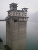
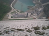
Zipingpu concrete face rockfill dam
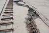
The 156m high Zipingpu CFRD is one of the largest CFRDs in China and one of the key projects for water supply and irrigation for the Chengdu basin. The dam was completed in 2006 and represented the latest CFRD technology in China (Figure 8). The dam was designed for an intensity of VIII (Chinese scale), with a design peak ground acceleration of 0.26g. The epicentral distance of the dam was 17km. During the earthquake the reservoir level was low and its volume was 300Mm3. Under normal operation conditions the reservoir volume is 1100Mm3. The crest of the dam and the concrete face were damaged. Of greatest interest was the damage to the concrete face and waterproofing system which consisted of damage of the vertical joints and the offset of the horizontal joint between the second and third stage slab construction (Figures 9 and 10).
After the earthquake the maximum settlement at the dam crest was 735mm and the horizontal deflection in downstream direction was 180mm. The cross-canyon deformation of both abutments was 102mm. Because of the low water level in the reservoir at the time of the earthquake, it is difficult to estimate what the earthquake behaviour of the dam, the concrete face, and the waterproofing system would have been if the reservoir was full.
Discussion of the earthquake hazard
The ICOLD Committee on Seismic Aspects of Dam Design has recently revised Bulletin 62 entitled ‘Inspection of Dams following Earthquake’. This bulletin can be used for the systematic inspection of dams that have experienced strong ground shaking (ICOLD, 2008).
For existing and new dams it is recommended a safety plan be prepared in which all hazards affecting a dam project are listed systematically and the action to be taken for each hazard is discussed.
As discussed earlier, the Wenchuan earthquake has shown the vulnerability of dams and especially appurtenant structures and spillways to rockfall, it is therefore necessary to pay more attention to this hazard in mountainous regions.
Among dam engineers, the concept of the maximum credible earthquake (MCE) or the safety evaluation earthquake is well known, however, the integral safety concept for dams, which includes the following elements: (i) structural safety, (ii) safety monitoring, (iii) operational safety and maintenance, and (iv) emergency planning, is less known to other people involved in dam projects.
In assessing the safety of slopes little reference is made to the stability of slopes at the dam site and the reservoir under the MCE ground motions. Usually the slope failure hazard is classified as moderate, small, and very small. Such a qualitative description is inadequate as it is necessary to discuss the different failure scenarios under very strong ground shaking and the consequences of such failures. The discussion of the consequences is often omitted.
The rockfall hazard is generally underestimated. Earthquake-triggered rockfalls and slides of steep slopes are usually shallow; therefore, protection of such slopes is technically and economically feasible.
For the seismic hazard assessment of dam sites and major infrastructure projects seismologists have developed sophisticated models. At present, the emphasis is on probabilistic seismic hazard analysis. The objective is to specify the hazard for different types of design earthquakes. The result is basically a uniform hazard spectrum for the acceleration at the ground/rock surface and a de-aggregation of the hazard in terms of magnitude and epicentral distance. The engineer would need the acceleration time histories of different design earthquakes. The last step, i.e. the conversion of the uniform hazard spectrum into different sets of acceleration time histories, is still under development.
As discussed in the previous section the seismic hazard is not only ground shaking. It is much more complex. Therefore, focussing on the ground shaking may not lead to an improved earthquake safety as other important hazards may be neglected. The situation is somehow comparable with the development of computer programs for the dynamic analysis of dams, which, although they were very advanced, the elementary information on material parameters and their strength properties was inadequate and there were, and still are, very large uncertainties involved in estimating the safety evaluation earthquake ground motion. It was realised that further progress in the methods of dynamic analysis would not lead to an improvement of the seismic safety of dams. Therefore, in the seismic hazard assessment of dam sites, a thorough study of all hazards is needed. Ground shaking may not necessarily be the dominant one.
The features of different types of dams to effectively resist seismic ground motion are listed in ICOLD (2001). To observe these general design recommendations is highly recommended as they are often more effective than any sophisticated dynamic analyses of a dam system where some of these guidelines have been ignored.
Large reservoirs and seismicity in Sichuan
Shortly after the 12 May 2008 earthquake, reports appeared which suggested that it was triggered by the impounding and operation of the Zipingpu reservoir. The main arguments for this suggestion are, firstly, the observation that large reservoirs can trigger earthquakes, secondly, that the epicentre of the Wenchuan earthquake is located 17km from the Zipingpu dam and, thirdly, a small part of one branch of the reservoir intersects the fault, which ruptured during the earthquake. However, if a tectonic fault is close to failure then it is almost impossible to determine the exact factors triggering a major earthquake. This is also the case for the Wenchuan earthquake. Additional research may shed more light into what triggered the earthquake. The following text was prepared at the seminar in Chengdu during the last day of the ICOLD-CHINCOLD mission.
The maximum water level of the Zipingpu reservoir (elevation 875.4m) has not exceeded the natural water level (elevation 877m) where the Min River crosses the Beichuan-Yinxiu fault. Therefore, the original hydrogeological conditions of the Beichuan-Yinxiu fault have not been affected by the impounding of the Zipingpu reservoir.
In August 2004, 13 months before reservoir impounding, an earthquake monitoring network with seven fixed stations was set up in the reservoir region. In October 2006, the reservoir water level reached elevation 875.4m, 1.6m below normal storage level. The corresponding reservoir volume was 900Mm3. In July 2006 and May 2007, the water level was lowered to elevation 820m. Before the Wenchuan earthquake (30 April 2008), the reservoir water level was at elevation 828.95m, the corresponding reservoir volume was 300Mm3. From the statistics of the annual seismic activity of the reservoir obtained from the Department of Reservoir Earthquake Research of the Sichuan Seismological Bureau, the frequency and intensity of seismic activity after impounding of the Zipingpu reservoir was almost unchanged before and after reservoir impounding. The recorded seismicity has also no relation with the reservoir water level variation.
This phenomenon is known as reservoir-triggered seismicity (RTS). The main mechanism for RTS is the release of tectonic stresses due to changes in stress and strength properties in fault planes caused by the reservoir. This requires that the fault that can produce an earthquake is already near to failure; so that the added weight or pore pressure build up due to reservoir impounding can trigger a seismic event. Seismic events can also be triggered by the collapse of underground cavities in mining areas or liquid injection.
Reservoir-triggered seismicity has been considered in the dam engineering community since 1935, when the first documented case of RTS was created at Lake Mead, the reservoir at the 220m high Hoover arch dam in the US. Since then several strong earthquakes in India, China, Greece and Zambia have occurred which are suspected of being reservoir triggered. The maximum magnitude of an RTS event that has been identified to date is 6.3. The exact number of reservoir triggered cases is not known but ICOLD believes that the number of accepted cases is today somewhere between 40 and 100. The relationship between reservoirs and seismicity continues to be debated in the scientific community.
The increasing height of dams and size of reservoirs may contribute to the possibility of earthquakes being triggered. ICOLD recommends that RTS needs to be considered for large dams over 100m in height. ICOLD has also published a bulletin presenting the state of knowledge on reservoirs and seismicity.
According to ICOLD recommendations, high hazard dams are designed to safely withstand ground motions caused by the maximum credible earthquake (MCE). Therefore RTS seismicity is not a direct safety problem for a well-designed dam as the maximum reservoir-triggered earthquake cannot be stronger than the MCE. However, RTS may still be a problem for other structures, buildings and appurtenant works because they may have a much lower earthquake resistance than the dam.
Adequate monitoring of RTS prior, during and after impoundment of a reservoir provides the most conclusive evidence as to whether or not water impoundment causes triggered earthquakes. To help distinguish between background seismicity and RTS, monitoring should start well in advance of impounding of the reservoir.
From the observational engineering viewpoint, the RTS cases are characterized by the following main features, which can be used as a checklist to determine if RTS is occurring:
• a) The seismic events monitored during and after impounding are more frequent than the background seismicity before impounding.
• b) With the increase and larger oscillations of storage levels, the frequency and magnitude of RTS phenomena increases.
• c) In most cases, the triggered events tend to be scaled down, after peaking, towards ambient background activity.
• d) In a number of triggered cases, the observed intensity of shaking sharply decreased with distance from the epicenters, which usually cluster around the reservoir. In most cases the activity starts soon after the beginning of impounding and grows with reservoir levels, restarting as a rule after quick changes in reservoir levels.
• e) It has been proposed to use as a diagnostic tool the relationship between frequency and magnitude of seismic events, with more smaller events indicating triggered seismicity, although this indicator is considered controversial.
• f) It is considered that more triggered events are linked to normal and strike slip faulting than to thrust faulting.
• g) Relatively shallow earthquakes are the most likely outcome of RTS. But, this statement has to be understood as a general trend, as significant exceptions are possible, as in the case of Aswan reservoir, where RTS phenomena were documented at a depth of 25km.
In the case of Zipingpu, on this basis the possibility of the Wenchuan Earthquake being RTS is very unlikely.
Conclusions
Based on the recent observations made in China, the following conclusions can be drawn:
1. Following a strong earthquake, the seismic hazard at dam sites have to be increased and the seismic design guidelines have to be reviewed and updated.
2. In mountainous regions large rockfalls have to be expected, which hinder access to dams after an earthquake for many weeks and months, and rockfalls can cause substantial damage to surface powerhouses, gates, piers, and appurtenant structures.
3. The earthquake hazard has many features which are site-specific, therefore a standard approach in which emphasis is only put on ground shaking is problematic.
4. The concrete face of CFRD dams are vulnerable to strong ground shaking mainly due to large in-plane forces.
5. Seismic instrumentation is still lacking in most dams, even in large modern dams.
6. Every time a strong earthquake occurs, new features show up which have been overlooked in the past by dam engineers.
7. Methods for the assessment of slopes in steep valleys subjected to very strong ground shaking need further development.
Martin Wieland, Chairman ICOLD Committee on Seismic Aspects of Dam Design, Poyry Energy Ltd martin.wieland@poyry.com
Chen Houqun, Vice-Chairman, ICOLD Committee on Seismic Aspects of Dam Design, Academician, China Academy of Engineering, China Institute of Water Resources and Hydropower Research, Beijing, China. chenhq@iwhr.com
The photos showing the damage and repair works of the concrete face of Zipingpu CFRD were obtained from Xu Zeping of IWHR, Beijing
TablesTable 1