Why did the road close for Traveston Crossing Dam?
30 June 2011Saleh A Wasimi gives an insight into the reasons behind the cancellation of what has been described as one of Australia’s greenest dams.
The severe drought at the beginning of the twenty-first century across southeast Queensland (SEQ), Australia has not been witnessed for more than a century. It prompted Brisbane, a metropolis of 2M people, in its desperate quest for additional water supply. After meticulous investigation of all possible options at the state government’s initiative, the Department of Natural Resources and Water came to the conclusion in 2006 that a dam on the Mary River near Traveston would be the best option with a desalination plant being a distant second.
The dominating factors in the selection of the Traveston Crossing dam (TCD), as it became known, were:
(1) It would provide the highest yield of any surface water option available in SEQ.
(2) Development can be staged to increase yield in future.
(3) The geographic location is appropriate to service Brisbane and the Sunshine Coast.
(4) The river has the highest discharge in the region with lowest storage and use.
(5) The catchment has the highest and most reliable rainfall in SEQ
(6) It would provide flood mitigation downstream including the town of Gympie.
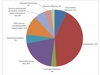
The long-term expected contribution of TCD in meeting Brisbane’s water demand is captured in Figure 2.
Work began in earnest to develop the project in 2006, and Queensland, being recognised as the exemplar of industrial best practice in its efforts during the construction of Wivenhoe dam, was well positioned to launch geophysical, environmental and socioeconomic studies for the project. It engaged reputable organisations such as the Commonwealth Scientific and Industrial Research Organisation (CSIRO) to research all facets of impacts and long-term consequences, and to recommend whether adverse effects can be adequately addressed for a viable future. Due diligence was exercised in the identification of all stakeholders and community consultation in all phases of environmental impact assessment (EIS). It was within the remit of the EIS to widely disseminate project updates and the EIS process through static displays and information days.
The design that was finally selected comprised a roller compacted concrete dam with a height above the foundation up to 52m, storage capacity of 153,000 ML, a surface area of some 3039 hectares, with the main channel of the Mary River to be inundated for a length of some 36.5km. Conventional mass and reinforced concrete spillway, flood gates, a fishway, a turtle ramp and a pipeline to connect to the northern water grid were part of the design. Some modifications to existing infrastructure were warranted; which were a major highway, a state road, a few local roads, telecommunications and power transmission/distribution infrastructure and some private structures, but no heritage listed or culturally sensitive properties nor any state or national forests or reserves would be affected.
From social impact assessments (SIA) conducted through consultation with different community representatives, surveys of residents in affected regions, workshops and information sessions in different towns in addition to collecting data available with government bodies, various community concerns were identified. These were:
• Loss of good farming land.
• Unemployment especially in the dairy industry.
• Impact on local businesses that supply and receive goods and services from rural uses (ie rural supply stores, equipment suppliers, mechanics).
• Displacement of farming families, some of which have lived in the Mary Valley for several generations.
• Difficulty for some farmers in getting work elsewhere or in alternative industries.
• Loss of the area’s rural heritage, relating to agricultural and timber industries.
• Potential increases in the price of produce, particularly milk and dairy products.
To address these community concerns, the project adopted the following:
(1) Voluntary purchase of land at market value and leaseback to owners with some restrictions on use such that the water quality in the reservoir does not degrade to unacceptable standards.
(2) Support community networks through funding and in-kind assistance through initiatives by incorporated community, sporting, recreation, education and cultural groups.
(3) A Worker Assistance Programme (WAS) would provide access to training, job preparation, relocation, and wage subsidy assistance for eligible workers who have lost their jobs as a result of the planning or implementation of the project.
(4) Business disturbance payments would be paid directly to affected businesses. A Business Assistance Scheme (BAS) for businesses indirectly affected would assist in development and implementation of strategies to improve their ongoing viability.
(5) Capacity building through assistance, research and development, subsidies, field trials, farm management education and training and workshops.
(6) Loss of opportunity for those who seek ‘tree-change’ (people who leave the city to follow a more rural way of life).
Environmental considerations stemmed primarily from the facts that the dam would inundate 3039ha of land, divert 4% of the annual flow of Mary River’s 2300T litres of average annual flow in addition to 6% of existing water entitlements, and interfere with terrestrial and aquatic flora and fauna. Two varieties of high nature-value terrestrial flora were identified, but the impact on those was expected to be minimal because of their extensive distribution. Seven endangered, vulnerable or rare (EVR) native fauna species were identified in the area, and the project included adoption of proven strategies for their continued existence.
The EVR aquatic fauna identified were Mary River cod, Queensland lungfish, and Mary River turtle – the latter two being critically endangered. The project plan included construction of a fish ladder and a turtle ramp. Further, to address the concerns of environmentalists for the critically endangered species, the project proposal included the construction of a A$35M Freshwater Species Conservation Centre.
After going through all approval processes of Queensland government and being labelled as the ‘greenest’ dam in Australian history, the project was finally scraped by the Federal Environment Minister in November 2009. The apparent reason being the opinion of two university professors to a senate enquiry on the performance of fish ladders and ramps, being not quite proven, and could push the critically endangered species to the brink of extinction.
Powerful people
If we carefully analyse the events that followed after the first public announcement of the plan in April 2006, we may perhaps be able to unveil more deep-rooted causes.
The project area was inhabited by some of the powerful people who left city life for tree-change. They had political acumen and organisation skills. They exploited the non-specific nature of the government’s approach to redress social concerns and, developed opposition at the grassroot level. To counterbalance, for example the unemployment concerns of the residents, the government could have specifically mentioned that jobs created would be filled by local people, and an outsider would only be hired if it can be proven that that particular expertise does not exist among the locals. This could have swayed the opinion of the vulnerable residents, and is important because experience elsewhere in the world has shown that jobs created from a dam project do not benefit the locals. If each individual’s concerns were personally addressed, people could have felt more reassured.
To address the concerns of the environmentalists, the government would have been better advised to have taken time to demonstrate that the measures they are adopting would work. Queensland lungfish (Neoceratodus forsteri), which has remained unchanged for over 100Myears, have very restricted habitat and low fecundity. A photo of the lungfish is given in Figure 3. They were translocated to several sites and did not persist in the Condamine River, Coomera River, Logan River and Albert River, but they have been spotted in the Brisbane River, North Pine River and Enoggera Reservoir. The government could have translocated and created favourable environment for Mary River cod, Queensland lungfish, and Mary River turtle in neighbouring rivers. Monitoring could have established beyond doubt that the fish could be sustained in these environments, and the opposition of the environmentalists wouldn’t have held water.
No doubt, such steps would have taken a much longer time and further commitment of resources, but a large dam is an irreversible imposition on nature, and therefore, deserves threadbare scrutiny. If environmental awareness of the public continues to grow as has been revealed in Australian elections during the past decade, the policy makers and planners need to pay greater attention to environmental and social issues rather than a predominantly economic and technical focus.
Associate Professor Saleh A Wasimi is the Head of Program, Mathematics & Statistics, CQ University, Rockhampton, Queensland, Australia. He has worked as a water resources consultant for the past 30 years for many organisations. His email address is s.wasimi@cqu.edu.au